MAPs Showing the Control of the British Raj:
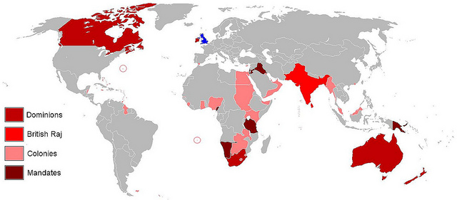
This picture depicts colonies and controlled areas of Britain in 1921, including the British Raj in India.

A picture showing the entire area controlled by the British Raj in Southeast Asia. Including not just India but also Bangladesh and Pakistan.
|

An in-depth map showing all of the territory the British Raj encompassed. This was the Indian Empire in 1893.
|
Bibliography:
Middle Right Picture:
Flag map of British Raj (Blue Ensign) by DrRandomFactor
http://upload.wikimedia.org/wikipedia/commons/thumb/7/7f/Flag_map_of_British_Raj_%28Blue_Ensign%29.png/283px-Flag_map_of_British_Raj_%28Blue_Ensign%29.png
Top Left Picture:
"British Empire 1921" by Vadac
http://upload.wikimedia.org/wikipedia/commons/b/b8/British_Empire_1921.png
Bottom Left Picture:
Map, "Political Map of the Indian Empire, 1893" from Constable's Hand Atlas of India, London: Archibald Constable and Sons, 1893. Uploaded byFowler&fowler«Talk» 23:20, 13 February 2009 (UTC)http://en.wikipedia.org/wiki/Presidencies_and_provinces_of_British_India#/media/File:IndiaPolitical1893ConstablesHandAtlas.jpg
